
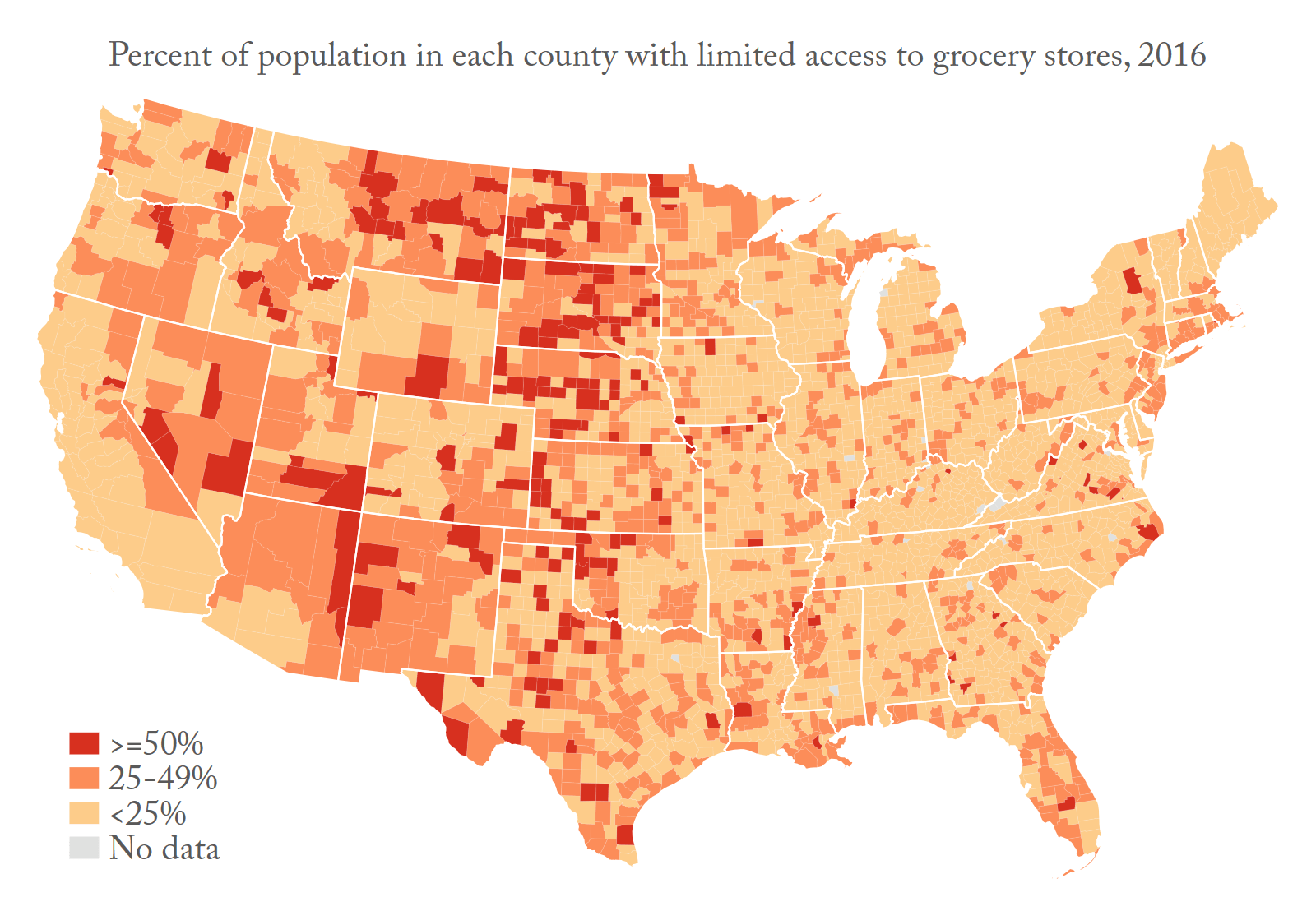
The USDA Food Environment and Access dataset provides information on geographic variation in access and proximity to grocery stores, restaurant availability and expenditures, food insecurity and assistance, food prices and taxes, and other food-related measures, as well as fine-grained data on food access for various demographic groups. The USDA dataset is derived from two data files: the Food Environment Atlas, which covers states and counties and spans the years from 2000 through 2016, and the Food Access Research Atlas, with measures from 2010 for census tracts.
The Food Environment Atlas’ stated objectives are to:
1. Assemble statistics on food environment indicators to stimulate research on the determinants of food choices and diet quality; and
2. Provide a spatial overview of a community’s ability to access healthy food and its success in doing so.
The Food Access Research Atlas is meant to:
1. Present a spatial overview of food access indicators for low-income and other census tracts using different measures of supermarket accessibility
2. Provide food access data for populations within census tracts
3. Offer census-tract-level data on food access that can be downloaded for community planning or research purposes
Data Summary
Dataset Name: USDA Food Environment and Access
Data Source: U.S. Department of Agriculture (USDA)
Years: Ranges from 2000 to 2016
Geographies: State, County, and Census Tract
Suggested Citation:
Jennifer Ailshire, Sarah Mawhorter, Matthew M. Young, and Yeon Jin Choi. 2020. Contextual Data Resource (CDR): United States Department of Agriculture Food Environment Atlas by State and County and Food Access Research Atlas by Census Tract, 2000-2016. Version 2.0. Los Angeles, CA: USC/UCLA Center on Biodemography and Population Health.
Related Publications
- Choi, Y. J., Ailshire, J. A., & Crimmins, E. M. (2020). Living alone, social networks in neighbourhoods, and daily fruit and vegetable consumption among middle-aged and older adults in the USA. Public Health Nutrition, 23(18), 3315–3323. https://doi.org/10.1017/S1368980020002475
- Guo, F., Bostean, G., Berardi, V., Velasquez, A. J., & Robinette, J. W. (2022). Obesogenic environments and cardiovascular disease: A path analysis using US nationally representative data. BMC Public Health, 22(1), 703. https://doi.org/10.1186/s12889-022-13100-4
- Henly, M., & Brucker, D. L. (2023). Changes in Life Satisfaction And Health for Rural and Non-rural Older Adults in the United States. Journal of Rural and Community Development, 18(4), Article 4. https://journals.brandonu.ca/jrcd/article/view/2241
Data Sources
Economic Research Service (ERS), U.S. Department of Agriculture (USDA). Food Environment Atlas, https://www.ers.usda.gov/data-products/food-environment-atlas/
Economic Research Service (ERS), U.S. Department of Agriculture (USDA). Food Access Research Atlas, https://www.ers.usda.gov/data-products/food-access-research-atlas/